Research Statement
The Ministry of Energy, Mines and Low Carbon Innovation’s 2019 Scientific Review of Hydraulic Fracturing in British Columbia report included a recommendation to increase water quantity and quality monitoring in NEBC. Concerns of Treaty 8 First Nations regarding water quality and quantity were also highlighted in the report, along with a need to incorporate Traditional Knowledge into research. The Pilot Collaborative Water Monitoring Program, Northeast BC aimed to collect water quantity and quality data to address recommendations in the report, as well as provide data for further uses such as groundwater-surface water interaction studies and watershed water balance studies. The Program worked with First Nations within the study area to collect Traditional Knowledge data, as well as to provide data collection training for First Nation representatives.
Goals
The Pilot Collaborative Water Monitoring Program, Northeast BC fits under Geoscience BC’s Strategic Objective of ‘Understanding Water’ and our goal:
- Measuring local and regional water balance.
The Program also fits under Geoscience BC’s Strategic Objective of ‘Demonstrating Research Value and Building Broader Support’ and our goal to:
- Increase collaboration with Indigenous groups and undertake relevant Geoscience BC research that fosters their socioeconomic development, while also supporting our objectives.
Benefits
In addition to collecting baseline data recommended in the Scientific Review of Hydraulic Fracturing in British Columbia report, this program aimed to combine the data from both Western science and Traditional Knowledge from First Nations in the study area and to build local capacity for monitoring surface water, groundwater and climate for future work. The Program provided an opportunity for each Nation to guide and access research that informs water use and resource development decisions in their traditional territories. The program provided an opportunity for Traditional Knowledge to be included alongside other data when assessing watershed health. The inclusion of Traditional Knowledge with Western science data can more accurately inform water management decisions and the co-management of water.
The new public data generated by the Pilot Collaborative Water Monitoring Program, Northeast BC has improved the understanding of surface water quantity, quality and availability in the region, and has provided supporting groundwater and climate data to assess watershed water balances and groundwater-surface water interactions for regulators, energy companies, communities, Indigenous groups and academia.
This pilot program has also provided lessons learned in expanding and/or adapting this type of project work in the future, as well as in further developing relationships with the First Nations involved.
Location
The study was conducted in BC’s Northeast Region, in the territories of the following Treaty 8 First Nations: Blueberry River First Nations, Doig River First Nation, Halfway River First Nation, McLeod Lake Indian Band, Saulteau First Nations, and West Moberly First Nations.
Geoscience BC encourages anyone planning exploration work to first contact Indigenous groups in the area. The Province of British Columbia’s Consultative Areas Database (https://maps.gov.bc.ca/ess/hm/cadb/) and The Association for Mineral Exploration (AME) provide a framework and guidance for engagement with Indigenous groups.
What Was Found?
Full details are included in the report and data available from the Deliverables section below.
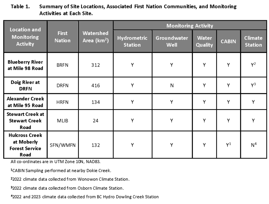
Five monitoring sites were chosen for this program in consultation with participating Treaty 8 First Nations. These sites are located at Blueberry River at Mile 98 Road, Doig River at Doig River First Nation, Alexander Creek at Mile 95 Road, Stewart Creek at Stewart Lake Road, and Hulcross Creek at Moberly Forest Service Road. Monitoring during the open water season occurred between 2022 and 2023. Hydrometric data and surface water quality were monitored at all five sites, with digital measurements taken every 15 minutes and manual discharge measurements taken several times through the season.
Groundwater monitoring wells installed close to the hydrometric stations recorded the groundwater levels and groundwater quality in the respective shallow aquifers. Where possible, boreholes were drilled to bedrock to confirm the presence of predicted paleovalleys. Surface and groundwater quality sampling was also conducted several times over the study period at the research . There were no water quality concerns identified in any of the water samples. Climate data was collected to support assessment of the water balance at four monitoring sites, generally recorded at 15-minute intervals.
Integrated time series plots for the monitoring sites, showing key climate, hydrologic and hydrogeologic parameters, are included in the Deliverables section below. Groundwater and surface water interactions were investigated at all sites except for Doig River, since no groundwater well was drilled at that site due to budget limitations. Shallow unconfined aquifers were monitored at Alexander Creek and Hulcross Creek. A bedrock aquifer was monitored at Blueberry River and a clay aquitard was monitored at Stewart Creek.
An analysis of benthic invertebrates (organisms that live in or on the bottom sediments of rivers, streams and lakes) using Canadian Aquatic Biomonitoring Network (CABIN) assessments at the five monitoring sites determined that these sites have abundant and diverse benthic invertebrate communities in healthy condition.
The Traditional Knowledge component of the program was supported by Integral Ecology Group (IEG) consultants, who have experience working with First Nation communities to collect Traditional Knowledge to support decision-making processes. McLeod Lake Indian Band and Halfway River First Nation participated in the Traditional Knowledge research component. Community members shared knowledge associated with changes in climate, changes in vegetation, changes in wildlife and key concerns regarding changes in water quantity. These culturally-based indicators are also presented in the deliverables as a report by IEG (Appendix G).